- Add to Favorites
-
Your web browser does not support
Add to Favorites.
Please add the site using your bookmark menu.
The function is available only on Internet Explorer

11Story
|
The Maluku Islands (Moluccas) |
|
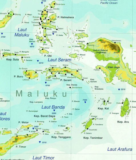
The Maluku Islands (also known as the Moluccas, Moluccan Islands, the Spice Islands or simply Maluku) are an archipelago in Indonesia, and part of the larger Malay Archipelago. They are located on the Australian Plate, lying east of Sulawesi (Celebes), west of New Guinea, and north of Timor. The islands were also historically known as the "Spice Islands" by the Chinese and Europeans, but this term has also been applied to other islands. Most of the islands are mountainous, some with active volcanoes, and enjoy a wet climate. The vegetation of the small and narrow islands, encompassed by the sea, is very luxuriant; including rainforests, sago, rice, and the famous spices--nutmeg, cloves and mace, among others. Though originally Melanesian, many island populations, especially in the Banda Islands, were killed in the 17th century. A second influx of Austronesian immigrants began in the early twentieth century under the Dutch and continued in the Indonesian era. Politically, the Maluku Islands formed a single province from 1950 until 1999. In 1999 the North Maluku (Maluku Utara) and Halmahera Tengah (Central Halmahera) regency were split off as a separate province, so the islands are now divided between two provinces, Maluku and North Maluku. Between 1999 and 2002 they were known for religious conflicts between Muslims and Christians but have been peaceful in the past years. |
 |
|
| Map of the Moluccas |
|
Spice Islands most commonly refer to the Maluku Islands (formerly the Moluccas), which lie on the Equator, between Sulawesi (Celebes) and New Guinea in what is now Indonesia, and often specifically to the small volcanic Banda Islands, once the only source of mace and nutmeg. The name Maluku is thought to have been derived from the Arab trader's term for the region, Jazirat al-Muluk ('the land of many kings').
The largest ethnic groups are the Malay, who live mainly along the coasts, and the Alfoer, who are concentrated inland. Less-numerous groups include Tanimbarese on the southern islands, Ambonese on the central islands, and Ternatan, Tidorese, Makianese, Tobelorese, Batjan, and Sawai on the northern islands. |
| << PREVIOUS SECTION << |